Amazon wildfire emissions up to three times higher than estimated
Wildfires that swept across the Amazon in 2024 were the most devastating in more than two decades. New research funded by the European Space Agency (ESA) suggests emissions may have been up to three times higher than earlier estimates.(source: www.esa.int).

Ethiopian volcanic plume
The Hayli Gubbi volcano in northeast Ethiopia, believed to have been dormant for up to 12 000 years, erupted on 23 November 2025, sending a massive plume of ash and sulphur dioxide high into the atmosphere. The Copernicus Sentinel-5 Precursor satellite has captured two images of this surprising eruption, one on 23 November and one the following day.(source: www.esa.int).

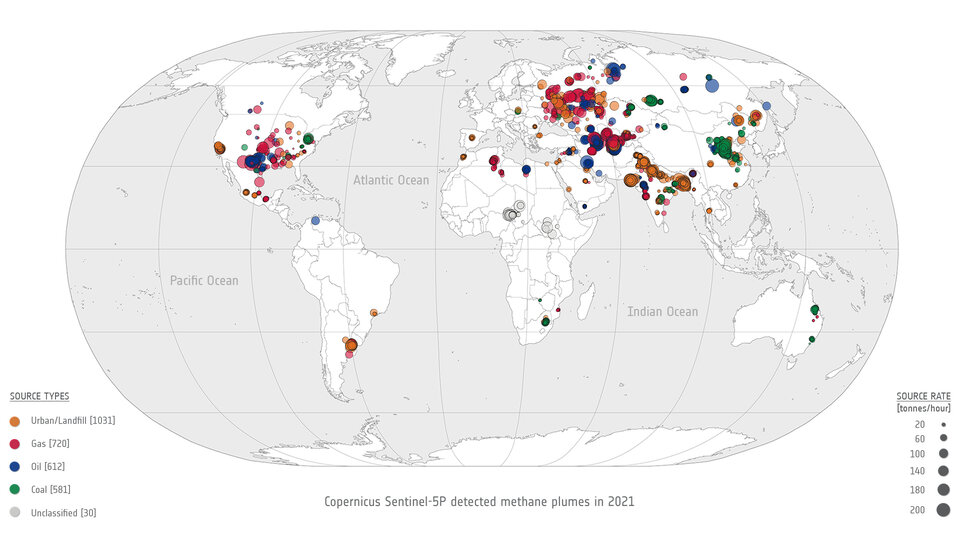
Top 10 persistent methane sources
A list of the top 10 global regions where natural or anthropogenic sources emit methane on a continuous, 'persistent' basis was recently published in a scientific journal. The study analysed data and measured emissions from hundreds of potential sources of methane based on satellite data. Data from the Copernicus Sentinel-5P mission was used to study and estimate methane emissions at 217 potential locations, as shown on the map below.(source: www.esa.int).

Ozone hole goes large again
Measurements from the Copernicus Sentinel-5P satellite show that this year's ozone hole over Antarctica is one of the biggest on record. The hole, which is what scientists call an 'ozone depleting area', reached a size of 26 million sq km on 16 September 2023. This is roughly three times the size of Brazil.(source: www.esa.int).

Trio of Sentinel satellites map methane super-emitters
In the quest to address climate change and reduce greenhouse gas emissions, detecting methane leaks – a potent contributor to global warming – has become increasingly vital. Researchers are harnessing the capabilities of cutting-edge satellite technology to monitor these leaks from space.(source: www.esa.int).
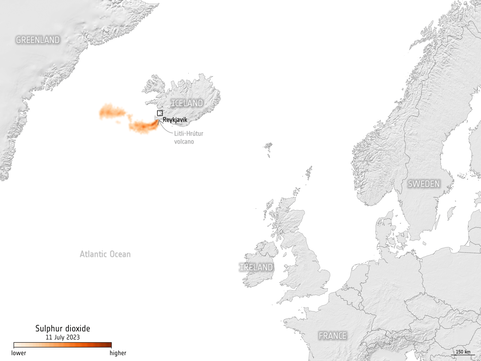
Litli-Hrútur eruption seen from space
On 10 July 2023, a volcano some 30 km from Iceland’s capital, Reykjavik, erupted following heightened seismic activity in the area. Satellites orbiting above us have captured the molten lava and smoke plume puffing from the Litli-Hrútur volcano.(source: www.esa.int).
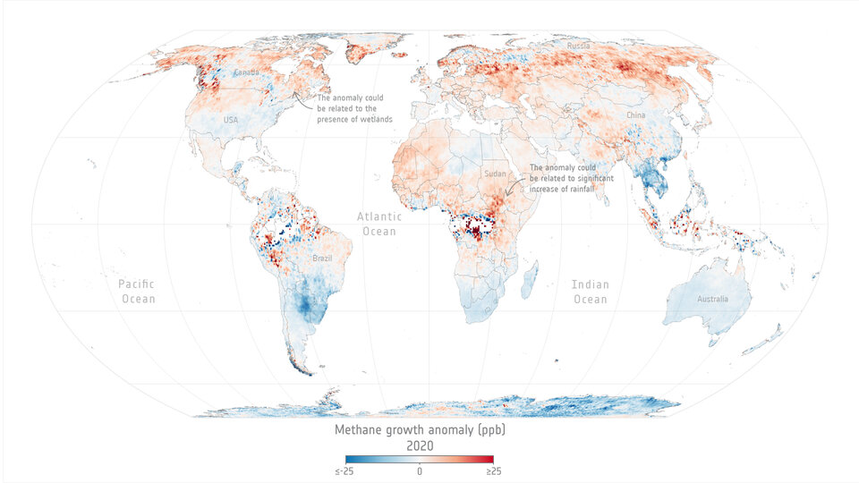
Methane levels surged in 2020 despite lockdowns
Levels of methane, the second most important greenhouse gas in our atmosphere, continued their unrelenting rise in 2020 despite the economic slowdown caused by the COVID-19 pandemic. A team of scientists, from the University of Leeds, have used data from the Copernicus Sentinel-5P satellite to pinpoint locations with large surges of methane emissions. These findings were presented during ESA's Living Planet Symposium which took place last month in Bonn, Germany. (source: www.esa.int).
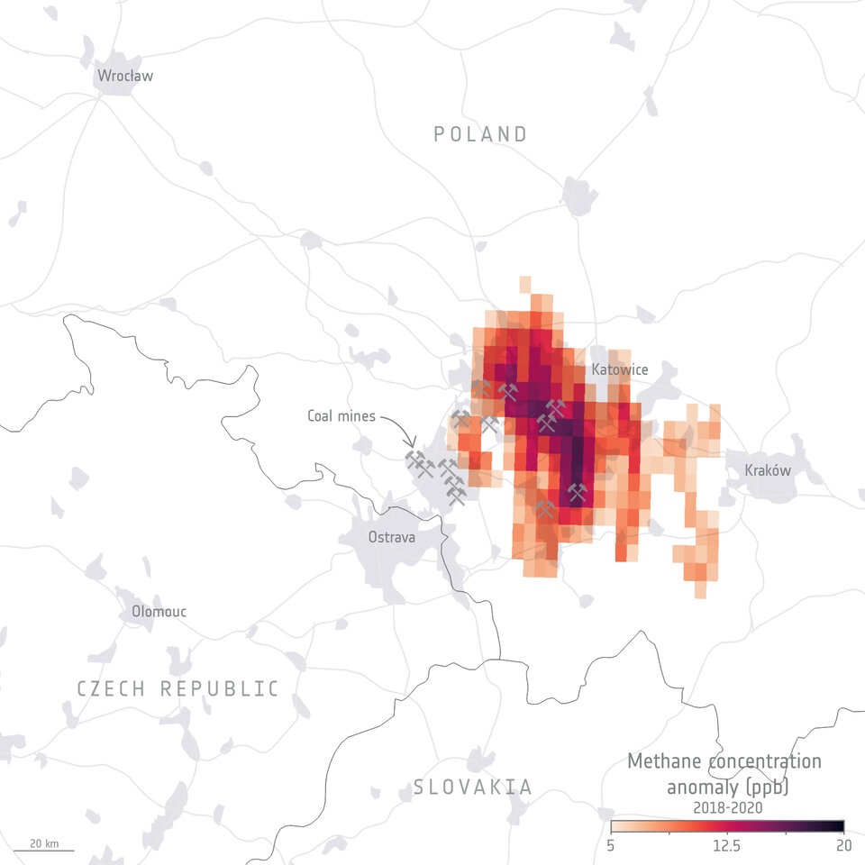
Methane detected over Poland's coal mines
Thanks to methane observations from the Copernicus Sentinel-5P satellite, we can now observe regions with enhanced methane concentrations from strong point sources all over the world. Satellite observations are a powerful tool for improving estimates of emission strength, seeing how they change over time and can also help detect previously unknown emission sources. Scientists from the University of Leicester have used data - generated by the University of Bremen - from the Tropomi instrument onboard Sentinel-5P to observe methane concentrations associated with key mining regions across Poland and demonstrate whether the satellite can capture coal mining emissions. (source: www.esa.int).
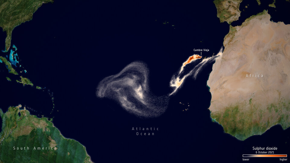
La Palma volcano: How satellites help us monitor eruptions
Since the Cumbre Vieja volcano began erupting on 19 September 2021, lava has burned through homes, roads and farmlands causing mass destruction on the west part of the Canary Island of La Palma. Satellite imagery has helped authorities monitor and manage the ongoing crisis. From capturing images of the rivers of lava, to measuring gas emissions and assessing damage, the fleet of Copernicus Sentinel satellites have been providing crucial data for local teams. (source: www.esa.int).
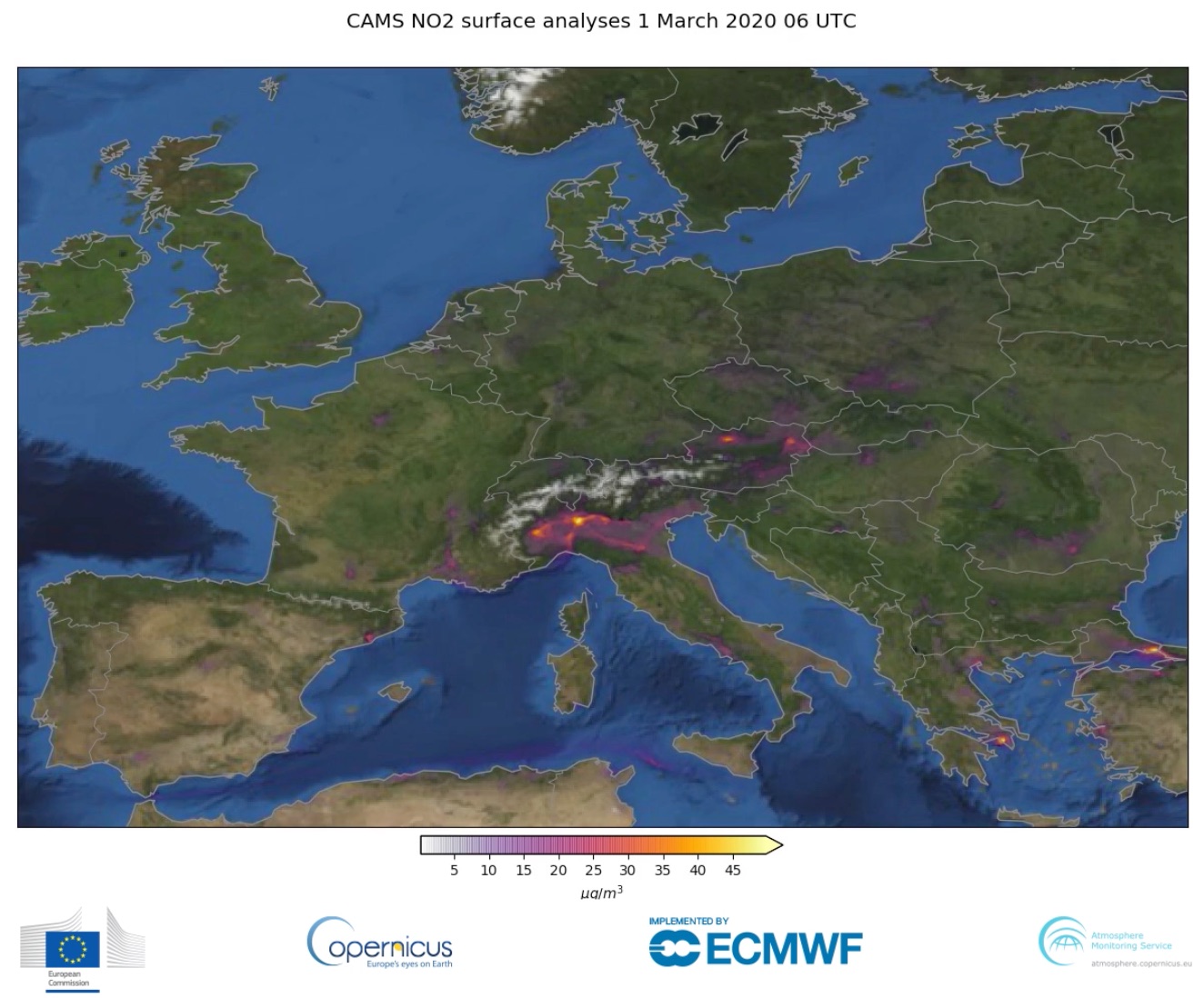
Measuring NOx levels as an indicator of economic activity
The monitoring of air pollutants from space has significantly improved over the past few years, providing ever deeper insights into the effects of economic activity, helping to find solutions to key societal challenges. The Copernicus programme is at the forefront of this task with the Copernicus Atmosphere Monitoring Service (CAMS), as well as with existing (Sentinel-5P) and upcoming (Sentinel-4 and Sentinel-5) Copernicus satellites. (source: www.copernicus.eu).
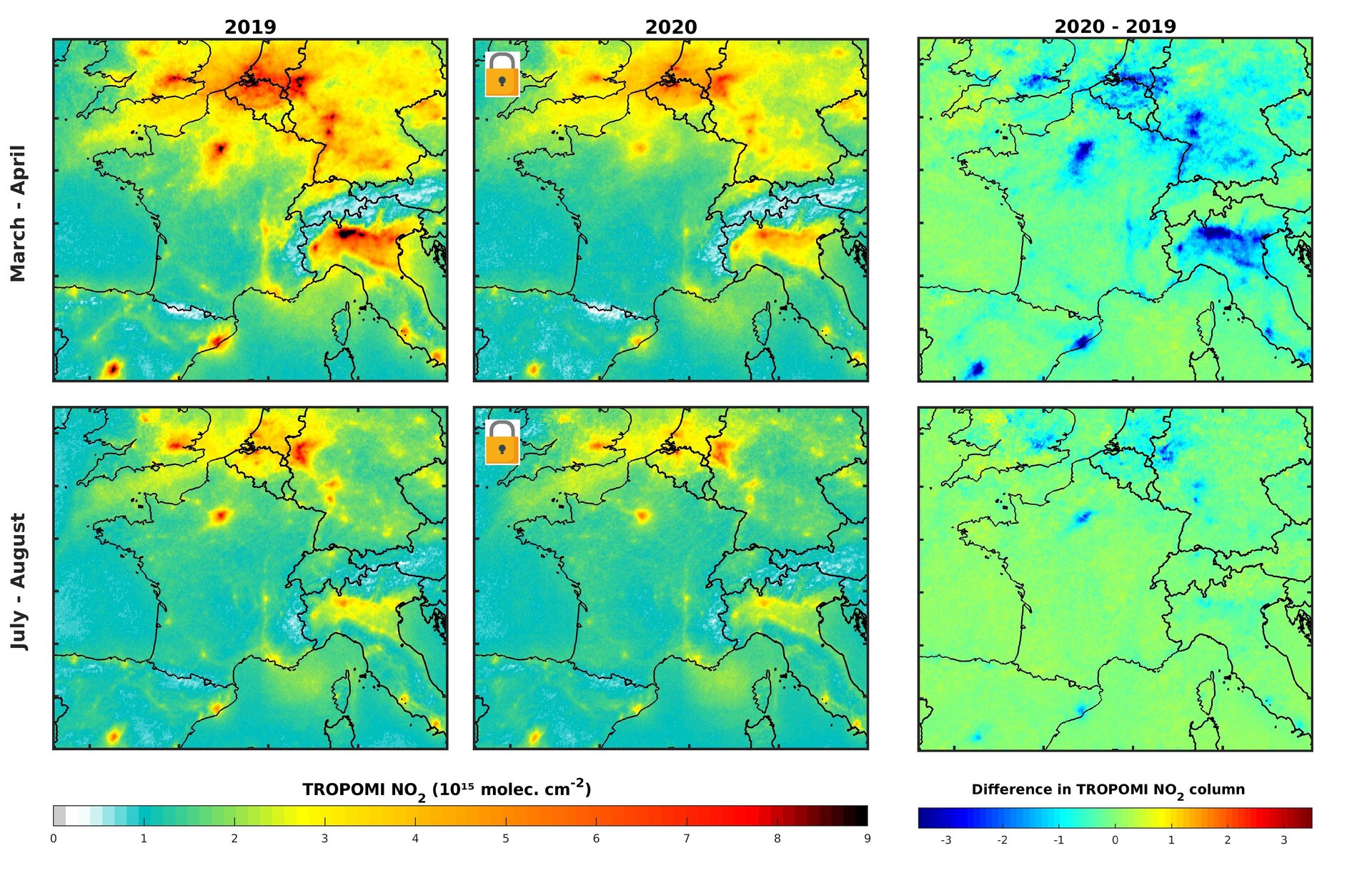
Air pollution returning to pre-COVID levels
In early 2020, data from satellites were used to show a decline in air pollution coinciding with nationwide lockdowns put in place to stop the spread of COVID-19. One year later, as lockdown restrictions loosen in some countries and regular activity resumes, nitrogen dioxide levels are bouncing back to pre-COVID levels. (source: www.esa.int).
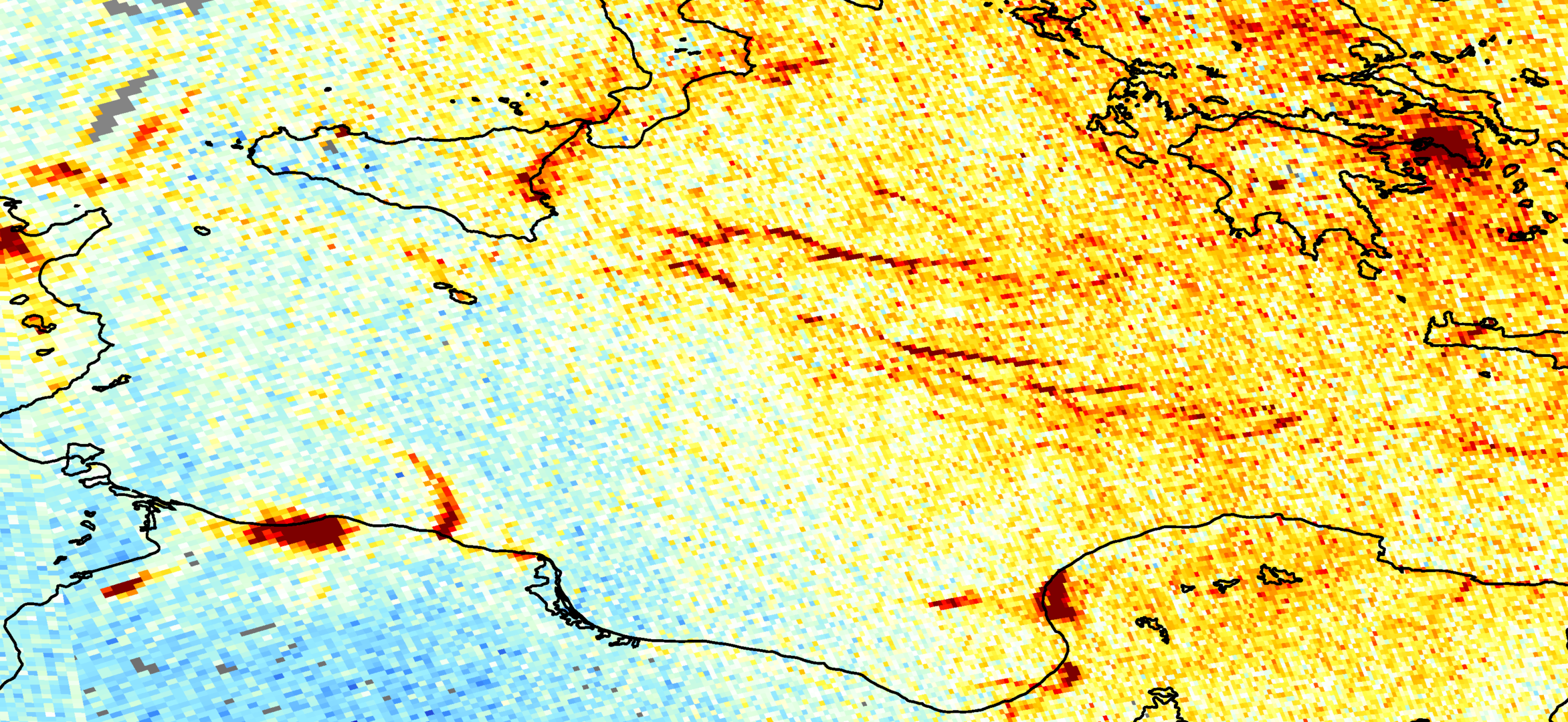
Detecting pollution from individual ships from space
For the first time, scientists, using data from the Copernicus Sentinel-5P satellite, are now able to detect nitrogen dioxide plumes from individual ships from space. Maritime transport has a direct impact on air quality in many coastal cities. Commercial ships and vessels burn fuel for energy and emit several types of air pollution as a by-product, causing the degradation of air quality. A past study estimated that shipping emissions are globally responsible for around 400 000 premature deaths from lung cancer and cardiovascular disease, and 14 million childhood asthma cases each year. (source: www.esa.int).
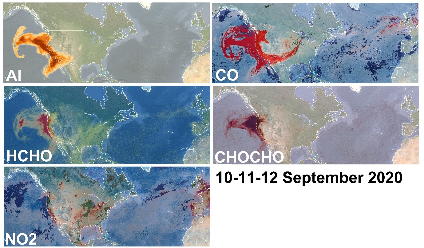
Copernicus Sentinels work together to monitor air pollution in recent US wildfires
California, Oregon and Washington State have been burning for over a month now, leaving most of the western United States under smoke—data from the Copernicus Sentinel-2, -3 and -5P missions are providing a wealth of complementary information, needed to monitor the blazes. Record high temperatures, thunderstorms and strong winds developed the critical conditions that allowed fires in western United States to spark and spread. Plumes of smoke from the fires were so extensive that they travelled across the US, reaching the opposite coast and even more incredibly also Europe, as depicted by NOAA. The Sentinel-5P satellite of the European Union's Copernicus Programme, dedicated to monitoring air quality, detected the increased concentrations of a series of air pollutants as emitted by the fires along the US west coast. (source: www.esa.int).
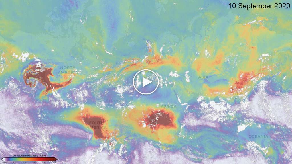
Animation of Sentinel-5P Carbon Monoxide for the month of September as generated by the Mapping Portal. (source: maps.s5p-pal.com).
Air pollution in a post-COVID-19 world
This year, satellite data have been widely used to monitor fluctuations in air quality brought on by strict COVID-19 measures. The Copernicus Sentinel-5P satellite, part of the European Copernicus programme, has been continuously mapping changes of air pollution since its launch in 2017. Scientists from the Royal Netherlands Meteorological Institute (KNMI) and the Royal Belgian Institute for Space Aeronomy (BIRA-IASB) have used satellite data from Sentinel-5P and ground-based data in order to pinpoint the correlation between COVID-19 and the effects of air pollution across Europe. (source: www.esa.int).
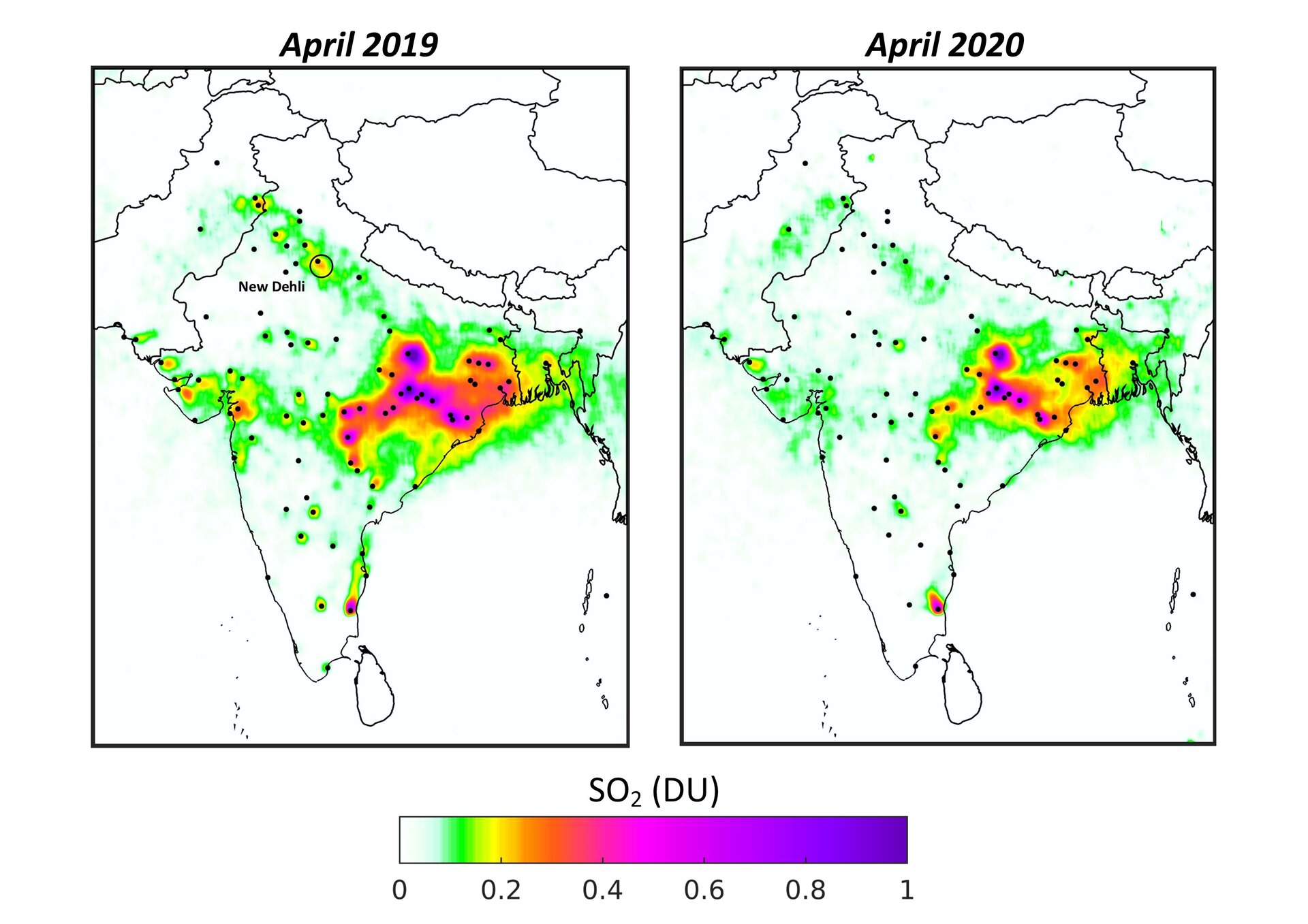
Sulphur dioxide concentrations drop over India during COVID-19
Concentrations of sulphur dioxide in polluted areas in India have decreased by around 40% between April 2019 and April 2020. Using data from the Copernicus Sentinel-5P satellite, from the European Union Copernicus programme, scientists have produced new maps which show the drop in concentrations across the country in times of COVID-19. (source: www.esa.int).
Detecting methane emissions during COVID-19
While carbon dioxide is more abundant in the atmosphere and therefore more commonly associated with global warming, methane is around 30 times more potent as a heat-trapping gas. Given its importance, Canadian company GHGSat have worked in collaboration with the Sentinel-5P team at SRON Netherlands Institute for Space Research to investigate hotspots of methane emissions during COVID-19. (source: www.esa.int).

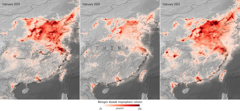
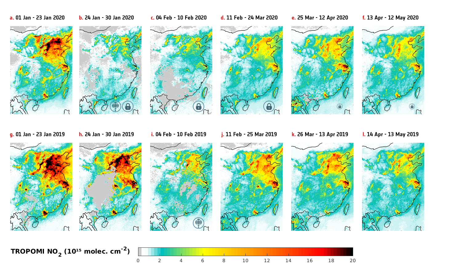
Is the global COVID-19-related drop in NO2 pollution coming to an end?
Now that COVID-19 mitigation measures are being relaxed in many countries the NO2 concentration is also increasing. Over China, the relaxation of COVID-19 measures brought the NO2 concentrations back to normal levels, as shown in the figure below (source: eo4society.esa.int).
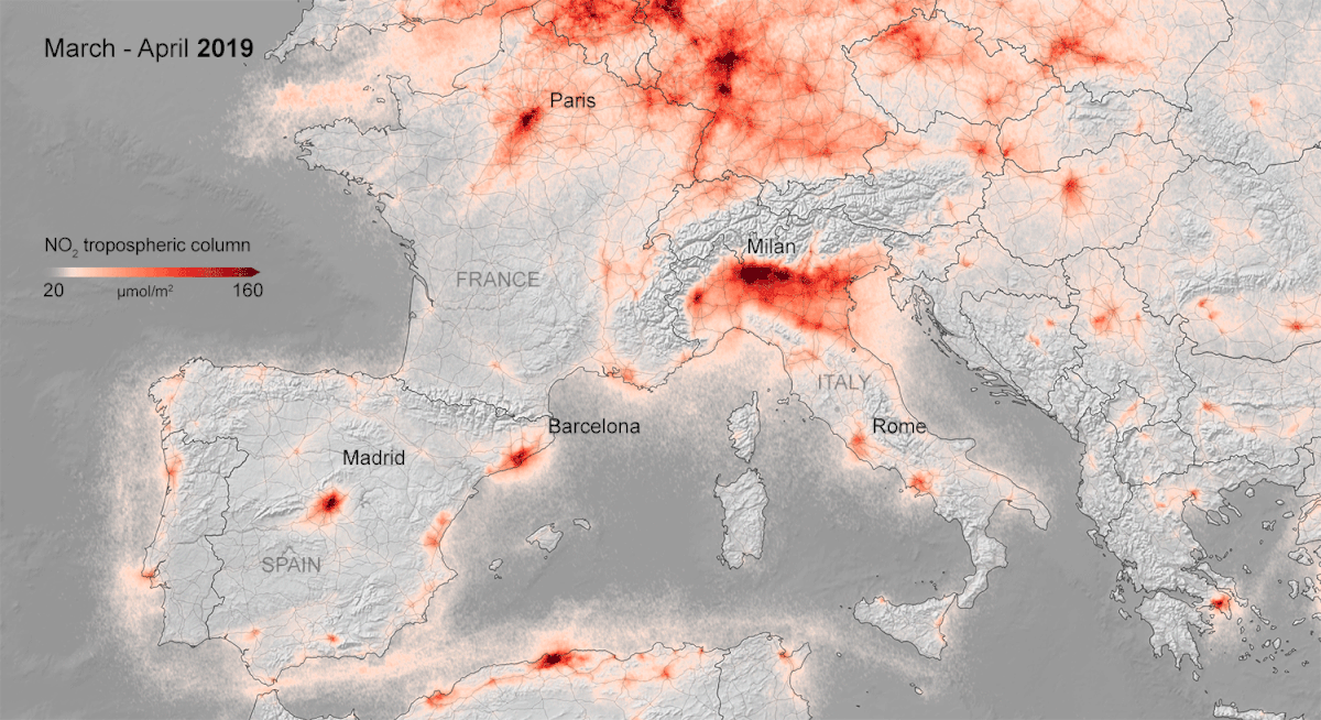
Coronavirus lockdown leading to drop in pollution across Europe
Copernicus Sentinel-5P satellite data are showing strong reductions in nitrogen dioxide concentrations over several major cities across Europe – including Paris, Madrid and Rome (source: www.esa.int).
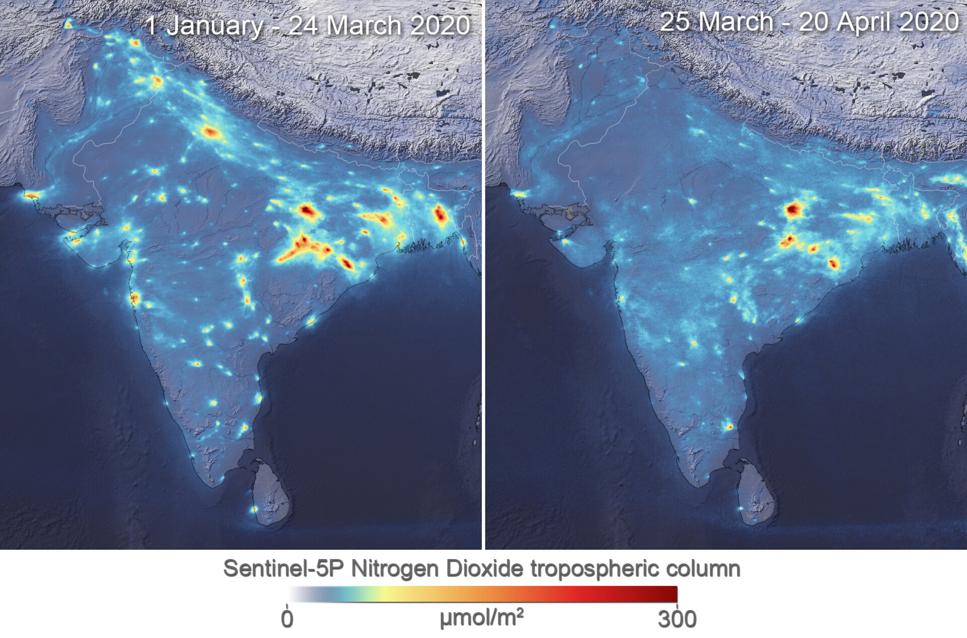
Air pollution drops in India following lockdown
Lockdowns imposed to halt the spread of the coronavirus have been recently linked with cleaner air quality over Europe and China. New images, from the Copernicus Sentinel-5P satellite, from the European Union Copernicus programme, now show some cities across India seeing levels drop by around 40–50% owing to its nationwide quarantine (source: www.esa.int).
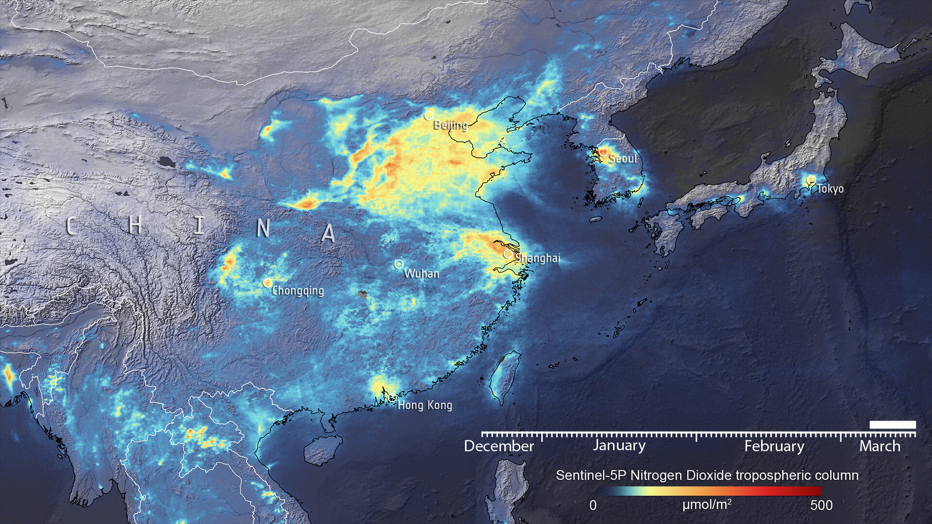
COVID-19: nitrogen dioxide over China
Recent data have shown a decline of air pollution over northern Italy coinciding with its nationwide lockdown to prevent the spread of the coronavirus (COVID-19). This new map shows the variation of nitrogen dioxide concentrations over China from December to March – thanks to the Tropomi instrument on board the Copernicus Sentinel-5P satellite (source: www.esa.int).
European Air Quality information in support of the COVID-19 crisis
CAMS is continually monitoring air quality in Europe and around the world using satellite and ground-based observations and advanced numerical models. In the context of the worldwide COVID-19 crisis, there is increased interest in changing air quality. (source: atmosphere.copernicus.eu).